On Sunday, October 30, mere hours after racing in the
Run for the Water road race, I got onto my Fat Boy and rode 3,100 miles in seven days. On this cold, crazy, trip I visited eight state highpoints and three capitols. This brings my totals to 35 and 25, respectively. Other than a relatively minor issue with the bike, some rain outside of Atlanta, and trying to keep warm when it was in the 40s, it was a fairly uneventful ride. I did run into a slight problem off the bike, but the only real harm done was a loss of time.
I left the house about 1pm on Sunday. I had a bacon cheeseburger as some recovery food from the run, and hit the highway. The first day's ride was rather uninteresting and one I've done before: TX-71 to I-10 East. It started out relatively warm- I was wearing my jacket loosely, and wearing my light gloves. After 6, when it started getting dark, I stopped to change from sunglasses to clear glasses and also put on chaps and my heavy gloves. It had already cooled off and it got progressively colder as I rode into the night. At 10 o'clock, I was quite chilled, and was satisfied to have gotten over 500 miles. I stopped for the night in Gulfport, Mississippi. It was a pretty cheap place, but I only needed a warm place for the night- it would have been too late to use the amenities a nicer place would have had.
I ate from the none-too-spectacular continental breakfast Monday morning. I killed about as much time as I would allow myself, hoping for the sun to get to work and warm the air up. I left around 9 bundled up as best as I could, but it was still quite cold. At least the sun was out, and there was a promise of the day getting warmer, which made it preferable to riding at night in the cold. I rode the interstate across the rest of Mississippi and Alabama, into Florida. I got off the interstate and actually crossed back into Alabama in order to access the Florida highpoint, Britton Hill. It was rather unimpressive- basically a small park on the side of the road. I arrived a little before noon. There were two guys sitting in a utility-type truck, but nobody else at first. A group of a few motorcyclists came later. I realized once I tried to take some pictures that I had completely neglected to charge my camera's battery before leaving, and it was totally dead. I took a bunch of pictures with the camera in my phone, and had a biker take one of me in front of the sign. The area seemed rather flat, so I walked around a little bit to try to make sure I had stood on
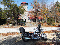
the highest point. I ate a PBJ before getting back on the bike and heading back to the interstate to head to Tallahassee. I had previously stopped for a picture of my bike in front of the Capitol on a road trip I took in 2004, but didn't take a tour. This time I parked, walked around the grounds, and took a quick tour of the "new" and "old" Capitols. I arrived about a quarter to 4, and they closed for the day at 4:30. Let's just say I wasn't sufficiently enamored of the place to need to stick around any longer. In the 1970s, the original Capitol had become too small for the government. It already had as many wings as it could support, architecturally, and they didn't think the foundation would support building up. So, they built a giant, ugly, office tower, as was the style of the time. They were planning to demolish the old Capitol, but preservationists spoke out, and the state removed the wings and restored the old building to its 1902 state. I started my tour with the 22nd-floor observation deck/art gallery of the new Capitol. I wasn't especially impressed with the view. I went down from there to check out the Senate and House galleries, and wander around the rest of the areas open to the public. After I felt I had seen the "new" Capitol, I went across a courtyard to quickly check out the "old" Capitol. It was nice, but not that spectacular. Still, it's too bad they couldn't figure out a way to keep using it.

Once I was done touring, I went back to my bike in order to get some pictures with it. At the garage, I got one of the few signs I saw all day that it was Halloween- a woman dressed as a witch. I found a spot (actually on a sidewalk) where I could kind of get my bike, the old, and new Capitols all in one shot (the old Capitol is mostly obscured by trees, however). Tallahassee was much warmer than anywhere else I had been all day, and the rush hour traffic did not make for the most pleasant riding getting out of town. I rode into Georgia, and kept going into the night. I stopped for the night at 9 (EDT now) just outside of Macon.
Tuesday morning was in the 40s again. I had my gear on, but it was still pretty cold on the bike. I rode through the rest of Georgia and into the northwestern corner of South Carolina. Just before getting to North Carolina, I went onto a nice tree-lined back road leading toward the state highpoint. The road got a lot narrower after an intersection, and ended at a parking area near the summit of Sassafras Mountain. I walked the short distance up a long disused road to the summit. The view was mostly obscured, and there wasn't much signifying the highpoint. I looked around and took a few pictures. The view was actually spectacular from a vantage point off of the parking area. The trees were a little past the peak "fall colors," but it still made a nice show. There was one car in the parking lot, and another pulled in while I was wandering around, but the first likely belonged to whomever was doing some work I could hear nearby, and the second never even really stopped. The road leading north off of the mountain into NC wasn't as well maintained as the road from the south, but it was still nice enough. I made my way to Asheville and then my GPS failed me trying to get to the Blue Ridge Parkway. It wasn't that far off, it just sent me through a residential area to go to an onramp that didn't exist. It was easy enough to make my own way onto the proper highway that lead to the BRP. While it had warmed up during the day, it cooled off quickly as I ascended into the mountains in the mid-afternoon. The view from the Parkway was quite spectacular. The road itself was well maintained and rather curvy. From the Parkway I turned into a state park with a road leading to Mount Mitchell, NC's highest peak. It got quite a bit colder as I climbed up even further. Near the top, there were spots of ice and very thin snow on the side of the road in the shadier spots. I parked and took a few pictures, then made my way up the path to the summit. It was an easy stroll, and there were several other people at the top.

At the summit are a sign, a tomb, and a stone structure with a ramp leading to its top. The tomb belongs to the mountain's namesake, who died while exploring the mountain and trying to prove that it was the state's highest point. The views are spectacular every direction from the summit. I took some pictures and had somebody take one or two of me, for my collection. My original route was just to head toward the Virginia highpoint, but I was really wanting to get out of the cold mountains before nightfall, and it didn't look like there were any sizable towns between the two highpoints. I instead had my GPS guide me to the town of Abingdon, VA. It was still dark and cold when I stopped around 8pm, but for once I decided to stay in a half-decent place. Once I got my stuff inside, I changed and went and warmed up in the hot tub. An additional luxury was sitting down and having an actual dinner at a pizza place next door. It wasn't great, but it was nice to have an actual meal for once. I also managed to pick up a charger for my camera's battery during the day, so I was able to charge it overnight.
Wednesday was another cold morning, but I finally wised up and put on every layer I had with me, adding long johns and a second pair of gloves and socks. I figured it would probably be overkill for the 8-mile round-trip hike to Virginia's highpoint, but it was a major help on the 40-mile bike ride to the trail head. I parked at the Massie Gap trail head and changed from riding gear to hiking gear. After about a half mile, the trail hooked up with the Appalachian Trail and followed it for about 2.5 miles before going onto a spur trail leading to the summit of Mt. Rogers. The trail got a little icy in spots in the trees. My trail running shoes weren't exactly the ideal footwear for the conditions. It was a major anticlimax once I reached the summit: I didn't realize it was the top so much because there was nowhere higher, but because the trail petered out. At first I tried to see where the trail went from there, until I realized I was at the summit. There wasn't a sign or anything, just a couple of survey markers on the two highest rock outcrops. There wasn't a view either, since it was heavily wooded. I took some pictures and ate a snack before heading back. Hiking back along the AT, I got lost at Rhododendron Gap. What happened was, I came up on a group of wild ponies that roam the area.

Not wanting to disturb them, I stepped off of the trail I was on. Unfortunately, there are several trails that lead to/from Rhododendron Gap. I got on one of those other ones, but almost immediately saw a blaze that didn't match the AT blazes. I didn't remember/realize that the AT actually did somewhat of a U-turn at this intersection, and I went straight. I didn't think I had come that way, but I wasn't entirely sure. After going a little way, I was pretty sure I was on the wrong track, so I went back to the intersection. The ponies were near some of the signs, and I didn't want to get too close. I saw one pointing north on the Appalachian Trail (toward Mt. Rogers), but not south (back to Massie Gap). Again not realizing I was at a bend in the AT, I went the opposite direction of AT North (the same wrong trail I was already on). I was almost certain it was the wrong trail, but I thought it was at least in the right direction. I didn't have a real trail map, just the rough map in my highpoint book, which didn't include the other trails. I hadn't brought my handheld GPS, and of course my phone had no signal to download a map or call anyone. I was only certain I was on the wrong trail when I came to a blaze of the wrong color, almost a mile from the Gap. I decided to go to higher ground, hoping I would see something I recognized or sign of civilization. What I did see was another trail. I followed that trail, and was thinking it might be the Rhododendron Trail, which also led to Massie Gap, because it went through a group of rhododendrons. Finally, after about another mile, I came to an intersection with another trail, and the first sign I'd seen since the Gap. It said whatever trail I was on would lead to the Appalachian Trail if I followed it for another mile. This seemed like good news. I had followed the AT, it should lead me back to where I started. However, once I did reach the AT, it didn't tell me which direction Massie Gap was. It didn't even offer north/south, and even if it had, I wasn't sure where I was relative to where I started to know which direction. I wandered around a little, onto a larger trail (it turns out it was the original wrong trail), before deciding my best course of action was to backtrack. I followed the second wrong trail all the way back to Rhododendron Gap. The ponies were still grazing, but I finally saw the correct sign pointing me back to where I started. The error added about 5 miles and two hours to what should have been a quick simple hike. It wasn't until I was almost back to the trail head that I saw people for the first time since I left my bike. I had sufficient supplies, and was anxious to be on my way, as well as being mad at myself, so I didn't try to engage with any of them. It was mid-afternoon, and I felt like I was way behind schedule. I changed back into biker gear and got on the road, going back through Abingdon, and heading toward the Kentucky border. It got dark before I made it out of Virginia. Just barely across the state line, I turned onto the little road leading to the KY highpoint, and, perhaps more interestingly, an FAA radar installation. The pavement (which wasn't in the best condition, but was passable) ended at the radar. I parked on the gravel and got out a flashlight to consult my guide book. I followed the gravel road to the left a short ways to the highpoint. There was a plaque and a tower whose lower flights of stairs had been removed. I did my best to get a couple of pictures and headed back to the bike. It was really dark out there on narrow twisting roads in coal country. The most frightening was an intermittent electrical problem. While I was riding along, with a car right on my tail, the bike went completely dead, no lights, for about a second, then came back and restarted from the momentum. The first time was scary, the second time was worse, because I likely exacerbated the problem by playing with the main on/off/accessory switch. Once I left it alone, the bike came back, and I pulled to the side to regain my composure and let the car go by. I crept along in the dark until I got to more populated areas. I stopped for the night just inside Tennessee at a cheap motel near the interstate.
Thursday I again suited up with long underwear, two pairs of socks and gloves. I made my way down toward Great Smoky Mountains National Park. While the park was beautiful, it was unfortunate I had to pass through Pigeon Forge to get there. It is surely one of the tackier tourist traps I've been through. There was some construction on Clingmans Dome Road, closing one lane. Fortunately it wasn't nearly as bad as the construction in Glacier NP, and it didn't hold me up for long. As I got closer to the top, the wind picked up and clouds rolled in, obscuring the view. I stopped in to check out the gift shop and suggested they could make a killing selling hot chocolate on a day like that. Apparently I wasn't the first to suggest that, but the logistics wouldn't allow for it, they claimed. I walked up the spiraling asphalt walkway to the summit. More like jogged, actually, trying to warm up. I took some pictures from the structure at the summit, but it was pretty much just of the inside of a cloud, and some nearby trees. There were a number of people going up and down the path, but there was nobody on the tower when I got there (not really any reason to stick around, I suppose), so I used the timer on my camera to get a photo. At the bottom, I ran into some people who took a shot of me with the tower in the background. I headed from Clingmans back into North Carolina (actually, since it's so close to the state line, I may have crossed a few times getting to/from the summit). I cut the corner of NC and was back in Georgia. The highpoint, Brasstown Bald, is in the northeast corner of the state. There is a road that leads to the building at the top of the mountain, but the last section is closed to the public and the only tourist traffic is via a shuttle bus. While it wasn't quite as cold that I desperately needed to warm up, my legs work well, so I walked from the parking lot to the summit. While there were a number of cars in the lot, and several people up top, the only person I saw on the path was a guy walking his dog. It was quite windy at the summit. When I set my camera on a railing to get a picture of myself (nobody else was spending any more time than necessary outside), it blew over onto the ground and did some damage to the lens. It still works alright, but it took several power cycles. There was a nice view up there, even though it was mostly overcast.

Unfortunately they don't allow access to the observation tower sprouting from the museum/theater on the main level, just the deck on top of that. I walked back down and bought some snacks and a "commemorative" t-shirt that was on sale. Down the road, near the town of Cleveland, I ran into the rain that had been threatened in forecasts. At first it was really light and I didn't do anything about it. A little further on, it started to pick up and I pulled over to put on my rain gear. In the next few miles, in a steady but not particularly heavy rain, my electrical problem happened three times. It was brief every time, but still it rather concerned me. I pulled over at a gas station, planning on waiting out the rain, and hoping that if things dried out it would be okay. I did also pull out my Harley directory to see where the nearest dealership was. I called one about 30 miles away, on my route toward Atlanta in Buford. They said they could look at it, so I got back on the bike and hoped I could make it safely. I made it to the shop with pretty much no further problems, but it was still raining, so I was nervous. They looked at it, and the fix wound up being pretty simple. For about $8 in parts and $60 in labor, they replaced a couple pieces of the ignition switch, and sent me on my way about an hour later. When I was checking out, I asked about the weather and the guy pulled up the radar on his computer. It did not look good. I wasn't on the road 10 minutes before I ran into the heavy rain. I could not see very well, looking through two layers of plastic covered in raindrops. I didn't have any waterproof gloves with me, and it was too cold to be gloveless, so my leather gauntlet gloves were soaked. It turns out my rain pants are past their prime, and the left leg below the knee barely even slows the water down. I felt as though I was way behind schedule, so I wanted to press on. On the northeast side of Atlanta, I decided I would stop for dinner and try to dry off a little while the storm passed. I didn't want to eat just anywhere, though, and I drove for a couple of miles once I got off of the highway before I found a place. The place I chose happened to be next to a hotel. Before I checked out the restaurant, I checked with the hotel to see what a room would run. It turned out to be pretty reasonable, so I decided I was done for the night, and got a room. I dried off and put on dry clothes before going across to get dinner. I wrung out a good bit of water from my gloves and set them out, hoping they would dry overnight. Dinner was pretty darned tasty, if a bit pricey, and a nice treat I don't usually get on the road. During dinner, it struck me why I felt like I was so far behind: I thought I only had 6 days to cover 3,000 miles, when I had planned for 7. I was only about 1,000 miles from home at that point, with two days to go, so there should be no problem getting home by Saturday night.
My gear was mostly dry Friday morning, and with no rain in the forecast, it seemed likely it would be completely dry before long. After breakfast and packing up, I had an embarrassing incident while getting gas. I somehow neglected to get the kickstand down fully, and the bike flopped over into the pump. It wasn't hard to get it back upright, and it didn't seem to have been damaged, but I felt like an idiot. Safely on the road, it was a short ride to downtown Atlanta, where I parked in front of the Capitol. Other than the gold dome exterior, it was fairly plain. It's a nice building, but other than portraits there isn't much artwork. The House and Senate chambers lacked most of the modern trappings most state legislatures have added, such as computer monitors and such. That's not necessarily a detriment in my book, but I wonder if it hinders their ability to work effectively in this day and age. From Atlanta, I rode west back into Alabama. A short ways off the interstate, I picked up the Talladega Scenic Drive, one of the nicer rides of the whole trip. It dropped me off in Cheaha State Park, where I rode up right in front of the stone structure at the state highpoint.
It's a nice old building, and the view from the top of the tower was really nice as well. I scouted around a little to try and find the highest "natural" point, and decided that it was a rock sticking up behind the building. While I had already had other people take a couple of pictures of me, I set my camera to take one of me standing on that rock as well. Since there was nobody taking the entrance fee at the station, I paid the $2 on my way out at the little store where I got a drink and snack. From the park, I continued on the scenic drive the way I had been going. I got to a point where my GPS expected me to go onto another road (without telling me about it), while the nice road I was on continued. Since I missed that turn, and the road I was on looked nicer anyway, I just kept on going. The maps in my GPS being quite old and out of date, it had no idea the road even existed, and was rather at a loss as to how to get me to Montgomery. I ignored it, until the lovely road all but ended, and quite suddenly. There were two roads from that point, neither of which looked very good. The one to the left looked slightly less bad, so I went that way. The road was rough, but taking it slow, I made it back onto genuine asphalt before too long, and my GPS was once again able to help me. I got to Alabama's Capitol in the early afternoon. I stopped briefly for a photo on the circular drive before parking across the street. While not exactly opulent, the Capitol was a little more decorated than Georgia's, with more statuary on the grounds, painted ceilings, and nice circular staircases. There actually wasn't a whole lot to see- the governor's suite is off limits, and the legislature moved out when the building was renovated years ago. They do have the old legislative chambers restored to their appearance in the 1870-1890 time frame, which one can wander through. After I felt like I'd seen the Capitol, I went across the street to the State House, which is where the legislature is now housed. Security was much more strict there, having to go through metal detectors and x-ray (whereas the Capitol you just walk right in). I started with the Senate, which is in a thoroughly contemporary style. I checked out the gallery, but when I went to the level of the building the Senate floor is on, the people working there seemed suspicious when I said I was looking around. The House was completely different. After checking out the gallery, I went down and I was encouraged to go on to the floor and look around. Once I'd seen enough of the State House, I went back to my bike and geared up to get back on the road. With no more points of interest on my itinerary, the only thing I had to look forward to was getting home. The ride from Montgomery was quite straightforward and boring. It was straight interstate- 65, 10, 12. I was near Mobile when the sun set and I switched to clear glasses. I pushed through Mississippi and stopped for the night in Hammond, LA around 9pm. I cheaped out once again and went for a low-rent motel instead of one of the more expensive places I priced first.
Saturday was a pretty boring ride. The only things of any interest were Harley shops I stopped at in Lafayette, LA and Beaumont, TX because I had the time, and they more or less lined up with gas stops. I got home mid-afternoon, before dark, and because I'm probably more than a little nuts, I
ran a 5k in the middle of the night, after some sleep, to take advantage of the end of Daylight Savings Time.


No comments:
Post a Comment