I woke up about 5 on Tuesday, took a shower, packed, and then stopped for breakfast at McDonald's about 7. I headed south through hilly roads, eventually turning off onto a side road toward the trailhead for Elbert. I stopped well short of the trail when the road got bad, took a picture and got back on the road. I wasn't completely sure the mountain I was looking at was actually Elbert, since it was curiously not marked anywhere that I saw, unlike many other mountains. I got in to Taos about 3 and got a room at the Best Western. I rode into town, its tiny roads jammed with traffic. I found it somewhat disorienting and it took me a little while to the brewpub I found on Google. The place was tiny and had a real hippy-type vibe. The beer and the food were pretty decent. The black clouds I'd been seeing since I got there seemed to be gathering and getting ready to soak the town, so I skipped the shops and went back to the motel, where I surfed the web and watched TV until I went to sleep.
Wednesday morning I took advantage of the surprisingly decent complimentary buffet breakfast and headed toward Taos Ski Valley. I went through the paved parking area for the easy route to the summit of Wheeler Peak and started up the gravel road to the parking area for the shorter distance, but more challenging route to the top. I paused when I saw a sign saying "Four Wheel Drive Vehicles Only," but then noticed it only applied during the winter months. There was quite a bit of construction going on, summer obviously being the off season in a ski resort. I took my time going up the gravel, but it was still pretty dicey. I contemplated stopping a couple times, but continued on to the next switchback. After one last ugly section I got spooked and parked in a switchback by another road going off somewhere else. I walked the half mile to the parking area for the Williams Lake trail. The sign said it was bear country, so I got out my bell since there was only one car in the parking lot at 8:30. I started on the trail but was feeling a bit lightheaded due to the altitude. I was thinking I'd get to the lake and have to turn around because of it, but was kind of surprised to get to Williams Lake, at 11,040 ft., ahead of my goal of 9:30. After some water and half a PBJ, I figured it was much too early in the day to turn back, so I headed up toward Wheeler. It started out kind of steep and I had to stop about every 100 feet of vertical gain to catch my breath, then it got a little steeper and the trail doubled as a stream bed. For a while, above what I estimated to be 12,000 ft., I was pausing every five steps for breath, but after a longer break I was back to pausing every 50-100 ft. At the end of the trail, 200-300 feet below the peak, it came to a steep scree slope. It was tough going, trying to find relatively solid places to step. I followed in the footsteps of a previous hiker for the most part. I figured the tracks must have been made that day since it rained the night before, but I never saw whoever made them. I finally made it up to the ridge, and it was awesome. The view was great and I felt good, like I still had energy. I set my pack down beside the trail and went up to what I was guessing was the peak. It was hard to tell since there was a peak to my left and one to my right, and they both looked about the same elevation from where I was standing. There was a sign on top of the one to my left, which turned out to be Mount Walter, but I went to the right first and after a small peak, the trail continued along the ridge to the actual peak.
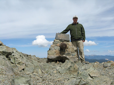 There was a small stone structure with a metal tube and a plaque, but not the usual ammo box for a summit register. It felt exhilarating having made the difficult trek. I took a bunch of pictures and went back to my pack for a proper rest and to eat. As I was sitting there a hiker, who had come up the easier route, came along the ridge. We chatted for a bit, then he went on to the peak and I headed back down the steep trail. It wasn't quite as bad going down as I thought it might be. I actually found it easier to go down the loose scree than the more packed sections. It was a lot quicker and less effort than going up, but it was murder on the shins. I had to stop a few times and sit down to give my legs a break. Once I got back down to Williams Lake there were several people there hiking around or sitting and enjoying the view. I hiked back down to my bike, stopping at a stream to wash up a bit. I was hoping to get a drink or something at The Bavarian restaurant, but despite its large "Restaurant Open" banner, it was not open. When I got to my bike, I changed shirts and socks and boots and took a minute to relax before braving the gravel road again. There were some black clouds in the mountains south of Taos. I pulled over to put on my rain gear, as much because I was cold as the threat of rain. Other than some wet roads I didn't hit any rain, but I kept the rain gear on because it was still cool. After dark I stopped for the night in Hereford, a little cow town. So much so that the whole place smelled like cows. It was after 10 but I was hungry, not having had dinner or much lunch, so I got a burger and vegged in my motel room.
Thursday morning I left with the sun low and it was still kind of chilly. I was a bit chilled just wearing a t-shirt, but knew it would warm up soon enough. It was up in the mid 90s by the afternoon as I was getting closer to Austin. I finally got to use my mister again for some relief. I got home at 4:30 and it was 91 degrees in my house. I turned the AC back on and laid down under the fan for a while before starting to unpack the bike and catch up on things.
No comments:
Post a Comment